Iceland Volcano: Updated Hazard Assessment -- Iceland Met Office
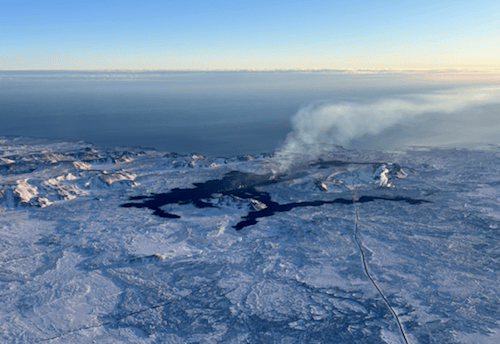 Lava from the eruption 8 February 2024. Photo: Birgir Vilhelm Óskarsson/The Icelandic Institute of Natural History.
Model calculations suggest that -- by the end of February or early March -- magma accumulation will reach a level similar to before the last eruption.
Information is updated regularly here and on X (Formerly known as Twitter).
Updated 20. February at 11:00 UTC
The Icelandic Meteorological Office has issued an updated hazard assessment map following the decision of the National Police Commissioner to repeal the order of a temporary evacuation from Grindavík, taking effect on 19 February, and due to the decision of the Police Commissioner in Suðurnes regarding changes in access restrictions for both individuals as well as business operations.
An updated hazard assessment map is valid from 20 February at 7 a.m. UTC, which is the same time as the decision of the Police Commissioner in Suðurnes goes into effect.
In the latest version of IMO's hazard assessment map, Zone 7 has been added in consultation with Civil Protection. Nesvegur Road is within Zone 7, which is currently more used to access Svartsengi and Grindavík. Hazards present in Zone 7 are fault movements and sinkholes. The colour code of other areas remains unchanged from the previous hazard map.
Read here about the decision of the Police Commissioner in Suðurnes. (Icelandic).
As before, the map shows an assessment of hazards currently at hand, as well as hazards that might occur with short notice. An assessment has only been made for hazards within the defined Zones, but hazards can also be present outside of them.
 The Iceland Met Office has published an updated hazard map, valid from 20 Feb. at 7 a.m. UTC. (Click on the map to make it larger)
- CategoriesEdited | All Content | Disasters | Earthquakes | Volcanos | Government | Science | Europe | Atlantic Ocean | News | News -- WNT Selected
- Date rangeTuesday, February 20, 2024
- Last modifiedTuesday, February 27, 2024
