


 A volcanic eruption started at Sundhnúks crater row at 21:26 UTC 22 August. This photo is taken one hour after the eruption started and the eruption fracture was estimated to be about 4 km long. Photo: Björn Oddsson/Civil Protection.
Updated hazard assessment
Updated 19. September at 17:00 UTC
Uplift at Svartsengi continues at a steady rate
Very little seismicity since the end of the last eruption
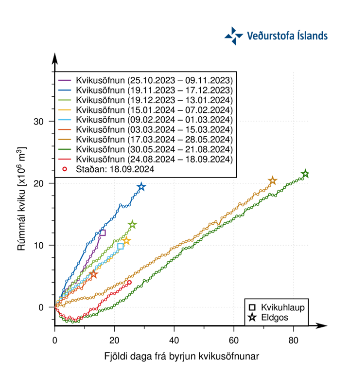
Updated hazard assessment. Valid until 3 Oct., barring any developments
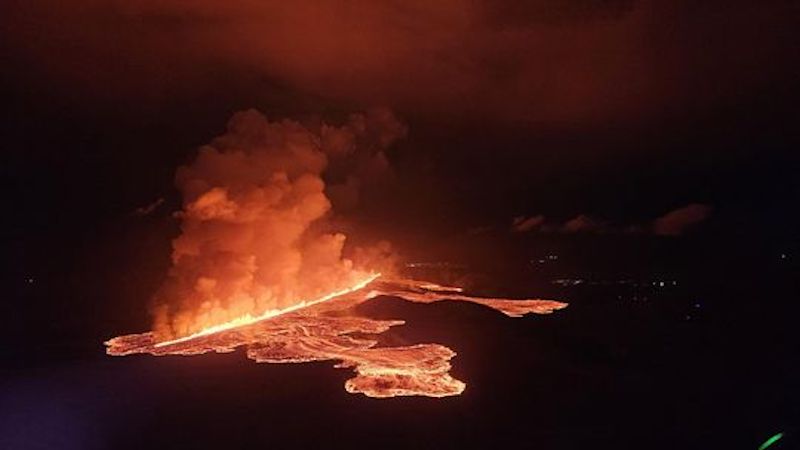
Two weeks have passed since the end of the last eruption in the Sundhnúkur crater row. GPS data indicate that the uplift in Svartsengi continues at a steady rate. Model calculations based on this data estimate that magma accumulation beneath Svartsengi also continues at a similar rate. This trend is similar to what has been observed between the last magma propagations and volcanic eruptions on the Sundhnúkur crater row.
As long as magma accumulation continues beneath Svartsengi and the amount of magma reaches similar levels as prior to recent events, magma propagation and even a volcanic eruption can be expected on the Sundhnúkur crater row. However, it is too early to say when that might occur. Looking at the last two events, it is unlikely that an event will take place in the coming weeks.
 The graph shows the estimated amount of magma that has been added in the magma reservoir beneath Svartsengi between the eruptions or magma propagations that have occurred since November 2023. The green line shows the development of the magma accumulation between the last two eruptions. The red line shows the development of magma accumulation after the beginning of the last eruption (22 August), which shows a similar development as the green one.
Updated hazard assessment
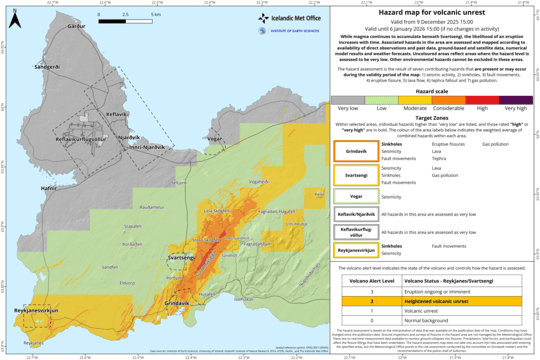
The Icelandic Meteorological Office has updated the hazard assessment, which is valid until 3 Oct., barring any developments.
Considerable changes have been made, the main ones concern the assessment of the hazard due to fissure movements and sinkholes, but these two hazards have been lowered for almost all zones.
The lava field is still very hot and the hazard from it is therefore considered high in the areas where lava flowed during the last eruption and gas pollution from the lava field is considerable. The hazard from tephra fall is now at the lowest level in all zones.

In the new hazard assessment, the overall hazard for Zone 4 – Grindavík – is assessed as “moderate” (yellow level), but the hazard due to sinkholes is assessed higher, or “considerable." The Icelandic Meteorological Office would like to point out that the Grindavík Committee is still working on fencing off and marking hazardous areas within the town. The hazard assessment does not take into account such mitigation measures that are considered necessary to prevent possible accidents or damage caused by the hazard that exists at any given time.
In addition to the hazard assessed by IMO, there are other factors that affect how much hazard is associated with staying in the town at any given time, such as limited escape routes, houses that can collapse, the hazard of damaged electrical cables, and due to construction work filling up fissures in the streets.
 Click on the map to enlarge

www.malaymail.com/news/world/2026/01/11/bomb-attac…
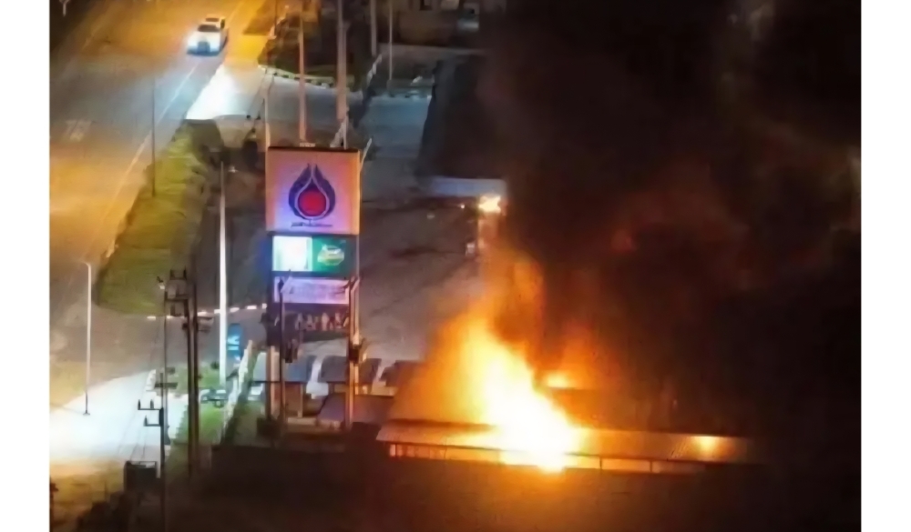
BANGKOK, Jan 11 — A series of late-night bomb attacks targeted 11 PTT petrol stations in Thailand’s southern border provinces of Narathiwat, Pattani and Yala…
www.khaama.com/at-least-eight-refugees-die-37-resc…

At least eight refugees died and 37 were rescued when their boat sank off Badmeli near Izmir, Turkish authorities said on Saturday.
katu.com/news/local/oregon-confirms-first-measles-…

Health officials in Oregon have confirmed the state's first measles cases of 2026, with two people diagnosed in Linn County.
abc11.com/post/measles-north-carolina-state-report…
Measles in North Carolina: State reports 5th case linked to South Carolina surge