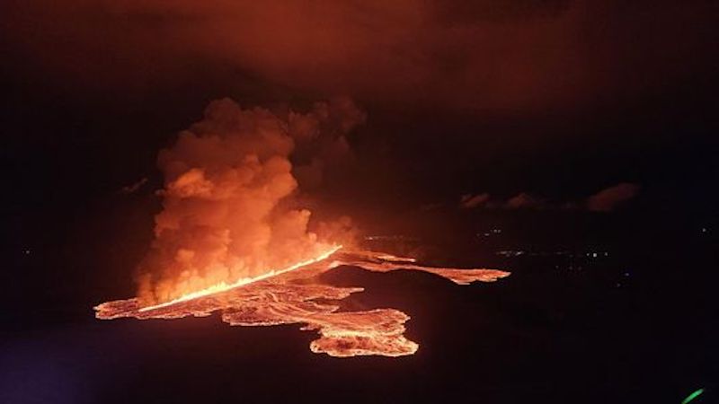
 The volcanic eruption started at Sundhnúks crater row at 21:26 UTC 22 August. This photo is taken one hour after the eruption started and the eruption fracture is estimated approximately 4 km long. Photo: Björn Oddsson/Civil Protection.
Land subsidence still detected at Svartsengi
Iceland Met Office
Updated 26 August at 17:30 UTC
- The eruption continues in the area northeast of Stóra Skógfell.
- The estimated extrusion rate at the beginning of the eruption is about 1.500-2.000 m3/s but is now significantly less, several tens of cubic meters per second.
- Land subsided about 40 cm when magma propagated from the Svartsengi reservoir into the Sundhnúkur crater row on the evening of August 22nd.
- All data indicate that this eruption is the largest since the autumn of 2023.
- The area of the lava field has reached 15.1 km2.
- According to the gas distribution forecast, there will be pollution from the eruption and wildfires in Svartsengi, Reykjanesbær and Vogar, among other places.
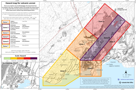
- Updated hazard assessment.
All data suggest that this eruption is the largest in the area since the unrest period began in the autumn of 2023. This assumption is based on measurements of the lava field so far and model calculations that estimate the amount of magma that propagated from Svartsengi to the Sundhnúkur crater row when the eruption started.
The eruption continues in the area northeast of Stóra-Skógfell. Over the past 24 hours, the activity has confined itself somewhat in one area in the northern part of the fissure that opened in the evening of 22 August. The lava now flows mostly to the northwest in two main streams and its progress has slowed down considerably.
 This map shows the extent of the lava as it was at 22:31 last night, August 25th. At that time, the area of the lava had reached 15.1 km2. The map is based on data from the Iceye satellite.
The estimated extrusion rate on 26 August was several tens of cubic meters per second. Precise measurements have not yet been carried out, but the assessment is based on comparisons with previous eruptions in the area and visual assessment of activity in the craters. At the eruption's first phase, the extrusion rate was estimated to be 1.500-2.000 m3/s. Therefore, the activity today is only a fraction of what it was.
When magma propagated from the Svartsengi reservoir to the Sundhnúkur crater row on Thursday evening, land subsided by a maximum of ~40 cm. That is almost twice as much as the subsidence measured on May 29 in the last eruption, which fits well with the fact that this is the largest event. The subsidence continues but at a decreasing rate day by day. If it is assumed that the extrusion rate of lava on Saturday was down to 100 m3/s, the decreasing rate of the subsidence indicates that the extrusion rate is now down to about ¼ of what it was. Model calculations suggest that 17-27 million cubic meters of magma have propagated from the magma reservoir beneath Svartsengi since the eruption began.
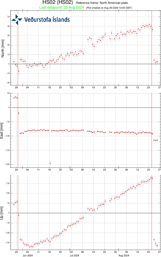 Time series from the GPS station HS02 at Svartsengi since the end of June 2024, in north, east and vertical directions (top, middle, bottom images, respectively). The bottom time series shows land uplift in millimeters. The red lines are the dates of the beginnings of the last eruptions, which started on 28 May and 22 August.
It is not possible to determine if magma flow will continue into the magma reservoir beneath Svartsengi until land uplift is detected. That could be after the extrusion rate is down to 4 m3/s or less, which is comparable to the inflow beneath Svartsengi as it has been estimated so far.
Seismic activity has remained low in the area and has been mainly detected in the northernmost fissure for the last 24 hours. One earthquake of M3.4 occurred close to Kleifarvatn just before midnight last night.
According to the weather forecast, slow easterly or variable winds will be at the eruption site today. Pollution from the eruption and wildfires is likely to spread throughout the Reykjanes peninsula. Pollution could be felt for a while, e.g. in Svartsengi, Reykjanesbær and Vogar. Tonight, southeasterly and easterly winds, 5-13 m/s which will transfer gas pollution to the northwest and west, over Reykjanesbær. Slower northerly or variable winds tomorrow afternoon can cause gas pollution in Grindavík area.
Updated hazard assessment
The Icelandic Meteorological Office has published an updated hazard assessment. Based on the development of the eruption in recent days and the gas distribution forecast, the hazard assessment has undergone some changes. The main change is in Area 1 (Svartsengi), which moves from high hazard (red) to considerable hazard (orange). It is believed that there is less hazard from lava flow but a greater probability of gas pollution and tephra fall. Area 7 moves from considerable hazard to somewhat dangerous (yellow), this is because there is less likelihood of lava flow and gas pollution in the area. The other areas are unchanged. However, a higher hazard is assessed due to possible tephra fall in Area 5.
 (Click on the map to make it larger)
Previous Updates
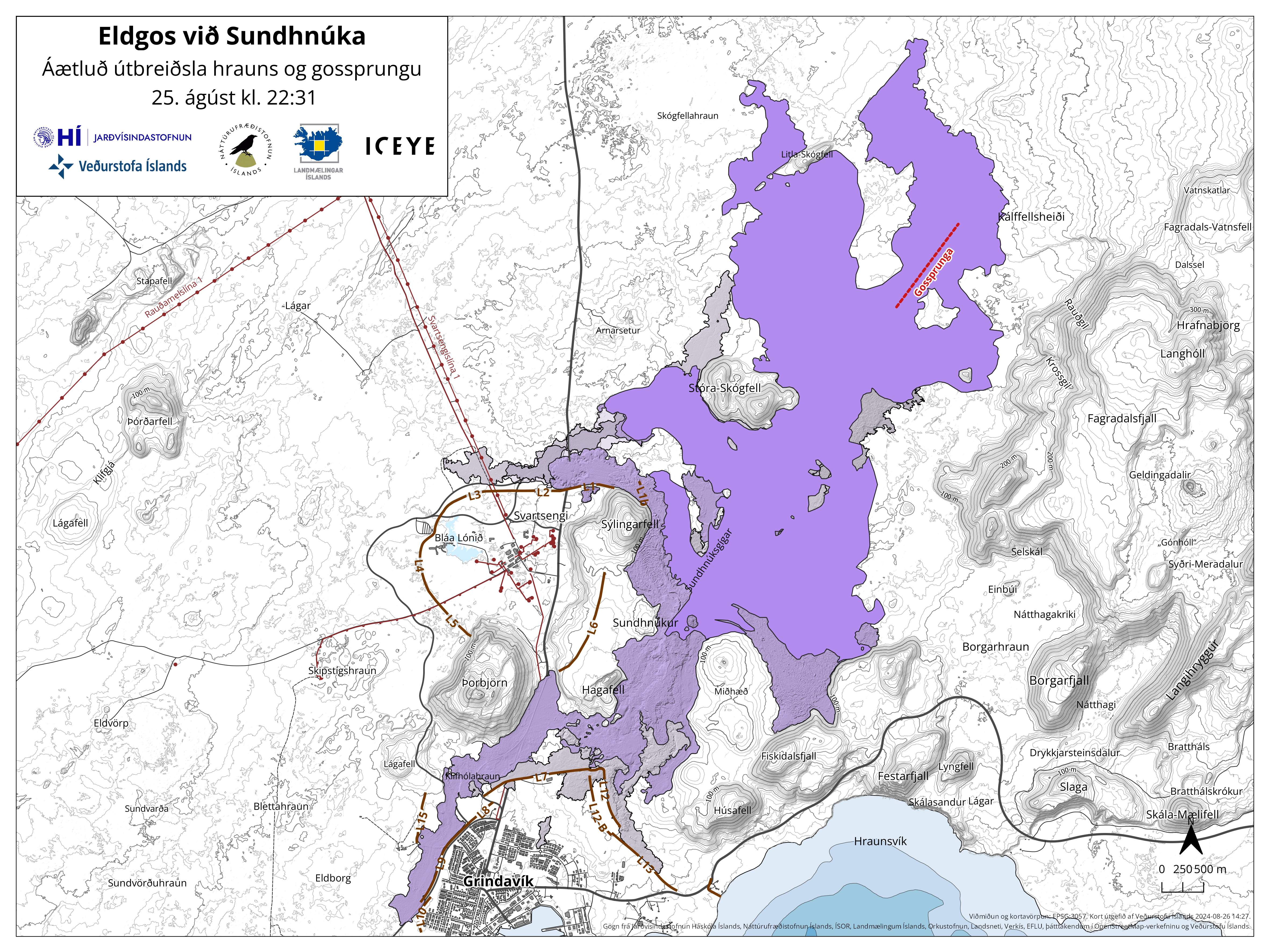 This map shows the extent of the lava as it was at 22:31 last night, August 25th. At that time, the area of the lava had reached 15.1 km2. The map is based on data from the Iceye satellite.
 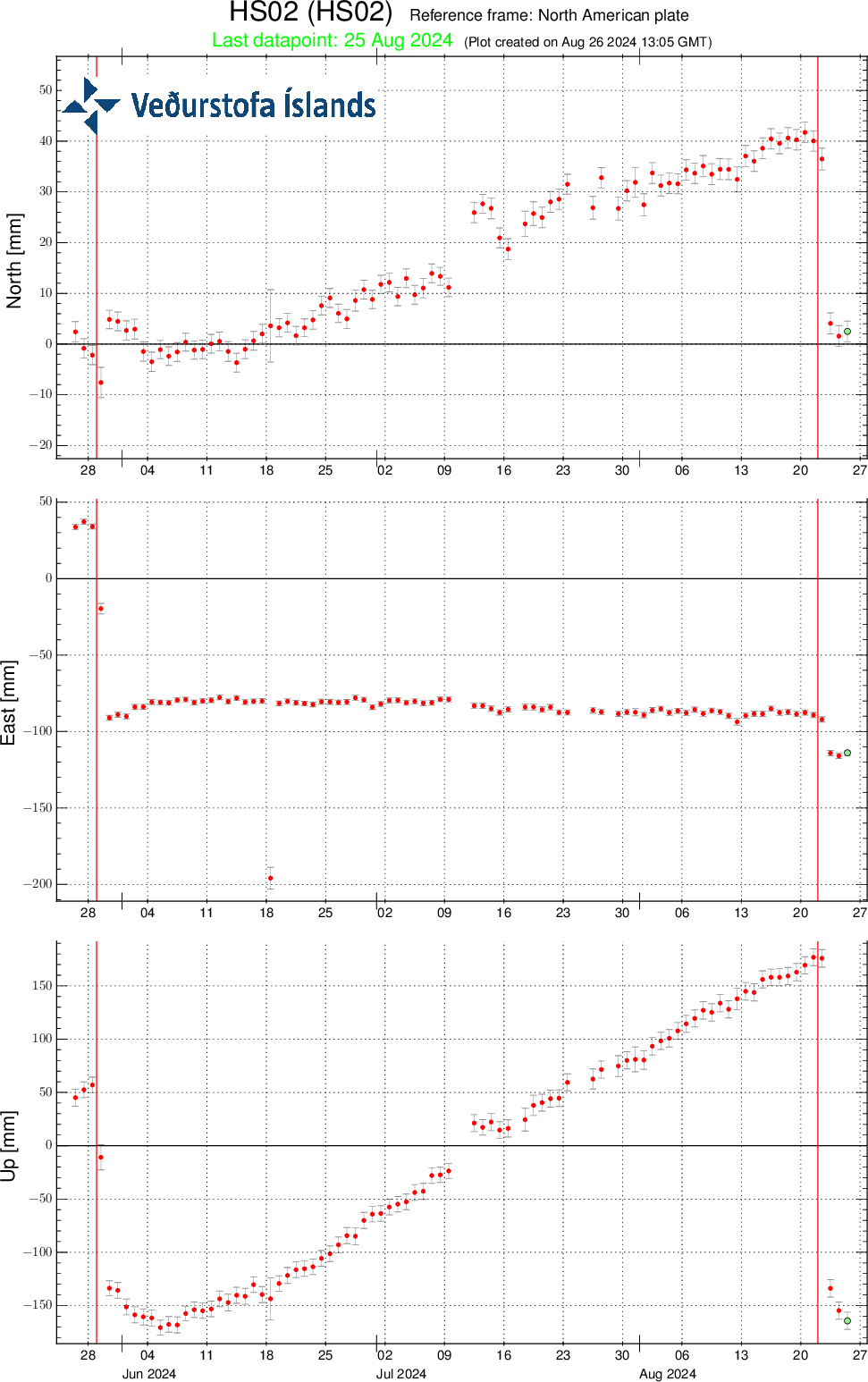 Time series from the GPS station HS02 at Svartsengi since the end of June 2024, in north, east and vertical directions (top, middle, bottom images, respectively). The bottom time series shows land uplift in millimeters. The red lines are the dates of the beginnings of the last eruptions, which started on 28 May and 22 August.
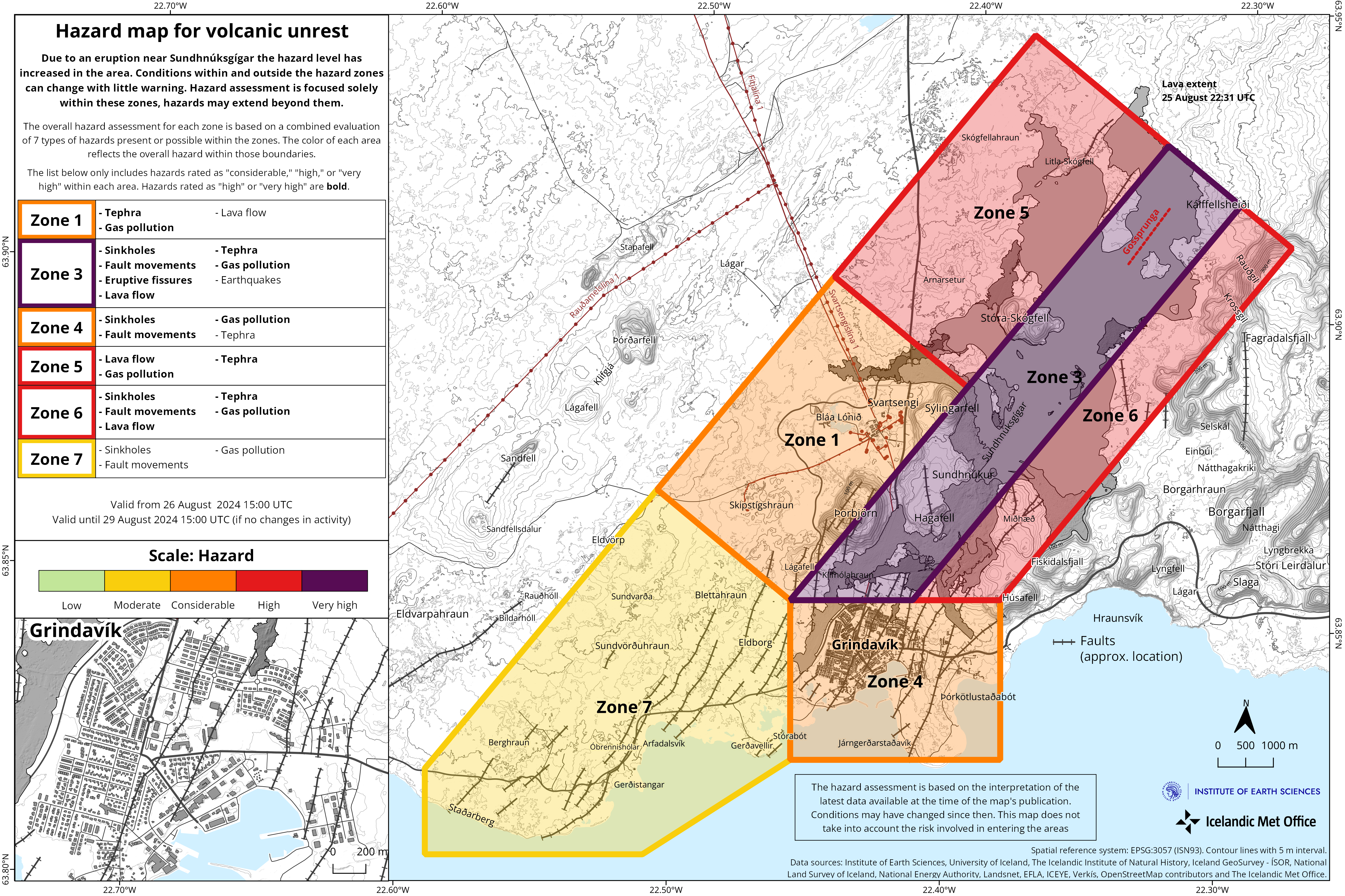 (Click on the map to make it larger)