Iceland Volcano: Continued Greater Chance Of Another Eruption -- Iceland Met Office
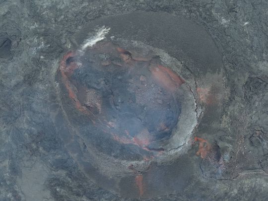 A picture taken on June 22 into the one crater that remained active until the end of the eruption that began on May 29. (Photo: Civil Defense)
Steadily increasing seismic activity suggests increasing pressure within the system
Updated 6 August at 15:30 UTC
The number of earthquakes per day on the Sundhnúkur crater row is slowly increasing
According to model calculations, enough pressure has built up in the system to trigger a new event
Hazard assessment remains unchanged from last week
The number of earthquakes per day detected on the Sundhnúkur crater row and the surrounding area continues to increase. About 60 earthquakes were detected in the last 24 hours. In comparison, the number of earthquakes just over a week ago was about 30 earthquakes on average per day.
The development of land uplift and magma accumulation beneath Svartsengi has remained similar for the past few days as the land uplift continues to decrease at a slow rate. That, together with increased earthquake activity indicates that pressure in the system is increasing. It remains to be seen how much pressure the crust can withstand before it brakes, and another magma propagation occurs.
According to model calculations, the estimated amount of magma in the magma reservoir beneath Svartsengi is comparable to what it was prior to the onset of the eruption that started at the end of May. Initial model calculations suggested that by the end of this week, the upper limit of amount needed to trigger a new magma propagation and even a volcanic eruption would be reached. The rate of uplift has decreased, which can result in a longer time window if a new event doesn't start in the next few days.
The updated hazard assessment issued by the Icelandic Meteorological Office remains unchanged and is valid until 13 August, barring any developments. The possible scenarios are also unchanged.

Scenario 1 - Eruption between Stóra-Skógfell and Sundhnúkur (central part of zone 3 on the hazard assessment map). Similar location to eruptions that began on 18 December 2023, 8 February, 16 March, and 29 May 2024.
- The likely precursor is a localized earthquake swarm between Stóra-Skógfell and Sýlingarfell, acceleration in deformation, and pressure changes in boreholes in the area.
- Very short pre-eruption warning time (less than 30 minutes).
- Lava could reach Grindavíkurvegur near Þorbjörn within 1.5 hours and Grindavíkurvegur near Svartsengi within 3 hours.
Scenario 2 - Eruption south of Sundhnúkur, near Hagafell, and extending south towards and potentially within northern Grindavík (southern part of zone 3 on the hazard assessment map and the northern part of zone 4). Similar location to the eruption that began on 14 January 2024.
- The likely precursor is an earthquake swarm starting near Stóra-Skógfell or Sýlingarfell and moving south, acceleration in deformation, and pressure changes in boreholes in the area.
- The warning interval for an eruption in this area would probably be longer than in scenario 1, but it is uncertain by how much. The length of the warning period depends on how far south the magma must break a pathway to the surface.
- Lava could reach Nesvegur and Suðurstrandarvegur within 1.5 hours. Lava flows could potentially close escape routes on land within about 6 hours.
- In this scenario, lava could reach the sea east of Grindavík within 1.5 to 3 hours. If lava reaches the sea, it could cause localized hazards due to rapid cooling of the lava. Initially, there would be a hazard due to ash and gas formation, primarily hydrochloric acid (HCl). Within a radius of about 500 meters from where the lava enters the sea, conditions would be life-threatening.
- A magma intrusion that reaches south of Hagafell will likely cause significant fault movements in Grindavík.
There is a possibility that lava could erupt within Grindavík. One scenario is that lava erupting from a vent north of the protective barriers at Grindavík could flow into existing fissures and then re-emerge again within the town limits. Another scenario is the possibility of an eruptive fissure opening within Grindavík. However, in such a situation, it is likely that a fissure would first open north of the town before opening within the town limits.
- CategoriesEdited | All Content | Disasters | Earthquakes | Volcanos | Government | Science | Europe | Atlantic Ocean | News -- WNT Selected
- Date rangeTuesday, August 06, 2024
- Last modifiedSaturday, September 28, 2024
